

Yacht club dock layout mapping is the process of digitally modeling and designing dock spaces to maximize usability, safety, and accessibility while supporting daily operational management. Done correctly, it transforms a static facility diagram into a living operational tool that drives slip revenue, member satisfaction, and regulatory compliance. Marina planners who treat facility mapping as an engineering discipline rather than a drawing exercise gain a measurable advantage in space utilization, staff coordination, and long-term infrastructure performance. This guide covers every component marina managers need to build, optimize, and maintain a dock layout map that actually works.
What is yacht club dock layout mapping and why it matters
Yacht club dock layout mapping, known in the industry as marina berth modeling or boating facility mapping, is the structured practice of capturing every physical and operational attribute of a dock facility in a digital format. Effective dock layout mapping requires a detailed digital berth model that includes docks, zones, slips, berth sizes, water depth, utility access, and vessel restrictions to enable reliable slip assignment and operational workflows. That structural layer then supports booking, allocation, pricing, and reporting across the entire marina operation.
The business case is direct. A well-executed harbor layout plan reduces double-bookings, eliminates manual slip searches, and gives dockmasters real-time visibility into occupancy. Integrated marina data with a bird's-eye layout reduces reactive management by improving planning, reducing communication errors, and supporting operational clarity for slip assignments. That shift from reactive to proactive management is the single greatest operational benefit marina planners report after completing a thorough mapping project.

Dock layout mapping is also an engineering and operational strategy that influences marina safety, usability, revenue, and sustainability on a multi-decade horizon. A poorly mapped facility creates problems that compound over years, not weeks.
Key components every dock layout map must include
Before any design work begins, marina planners need to collect and structure the foundational data that will drive every downstream decision. Missing even one data category creates gaps that surface later as booking conflicts, safety incidents, or compliance violations.
Physical berth attributes form the base layer of any marina dock design:
- Slip dimensions: length, beam, and depth for each berth
- Water depth at mean low water and mean high water
- Utility connections: shore power amperage, water, pump-out access
- Vessel restrictions: maximum length overall, draft limits, and beam clearances
- Dock type: fixed timber, aluminum floating, or modular composite
Environmental and basin factors must be assessed before finalizing any yacht marina layout:
- Wave exposure and prevailing wind direction
- Tidal range and water-level variation (floating docks are preferred when water-level variation exceeds 0.5 m)
- Current patterns and sediment movement
- Breakwater and basin protection adequacy
Accessibility compliance is non-negotiable. ADA boating provisions require accessible slips dispersed across different slip types and boarding configurations, not concentrated in one convenient location. The number of required accessible slips scales with total slip count and must cover a variety of slip characteristics. Concentrating accessible berths in a single zone is a compliance failure that also excludes specific vessel classes from fair access.
| Data Category | Key Attributes to Capture |
|---|---|
| Berth dimensions | Length, beam, depth, clearance |
| Utilities | Shore power rating, water, pump-out |
| Environmental | Tidal range, wave exposure, current |
| Accessibility | ADA slip count, dispersion, boarding type |
| Operational | Staff zones, fuel dock location, launch areas |
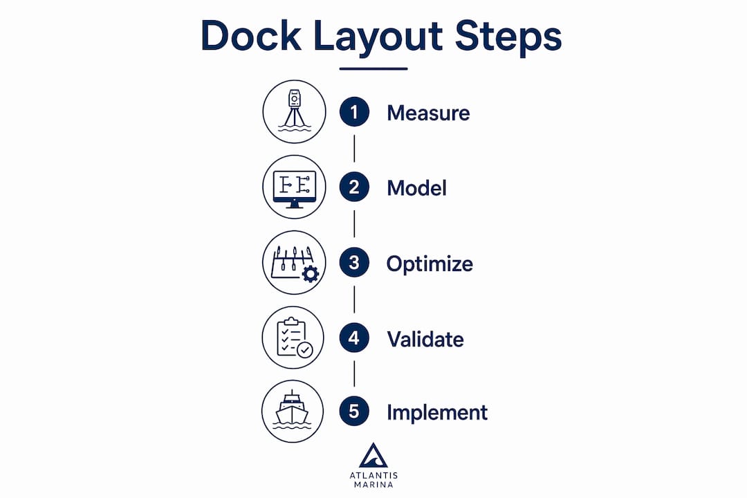
Pro Tip: Before modeling anything digitally, walk every dock with a measuring tape and a depth sounder. Field measurements routinely differ from original construction drawings by 5 to 15 percent, and those discrepancies cause real booking conflicts once the system goes live.
How to build and optimize a dock layout map step by step
With foundational data collected, marina planners can move into active design and optimization. The following process applies whether you are mapping an existing facility or designing a new one from scratch.
-
Build the digital berth model. Assign each slip a unique identifier and attach all physical attributes: dimensions, depth, utility specs, and vessel restrictions. Treating berth attributes as structured data linked to vessel size, permits, and location preferences enables automated conflict detection and realistic slip availability in reservation systems.
-
Map zones and circulation paths. Define dock zones by vessel type or membership tier, then map fairway widths and turning basins. A 10% reduction in fairway width impacts safety and efficiency in ways that are difficult to reverse without major reconstruction.
-
Optimize slip count and configuration. Maximizing effective dock capacity involves reducing wasted gaps, placing finger piers efficiently, matching slip sizes to actual boat demand, and choosing dock angles that support safe movement. Reviewing your current vessel registry against slip size distribution often reveals that 20 to 30 percent of slips are mismatched to the boats actually using the facility.
-
Align dock orientation with environmental conditions. Orient main fairways parallel to prevailing winds where possible. Run hydrodynamic modeling to confirm basin protection is adequate. Under-protected basins cause structural fatigue in floating dock systems that shortens infrastructure lifespan by years.
-
Test accessibility dispersion. Run your accessible-slip selection logic against the full slip inventory to confirm ADA-compliant berths are distributed across dock sections, vessel size categories, and boarding configurations. Testing accessible-slip logic against actual slip dispersion avoids exclusion of boat classes and protects the facility from compliance exposure.
-
Link the map to operational workflows. A reliable digital twin berth model must link physical berth attributes with operational workflows for dock preparation, utility checks, and arrival coordination to reduce staff coordination time and booking conflicts. The map without the workflow link is just a picture.
-
Validate and iterate. Review the completed layout with dockmasters, harbormaster staff, and a sample of members. Field feedback consistently surfaces circulation problems and workflow gaps that no software model predicts.
Pro Tip: Build your slip size distribution to match your five-year vessel demand forecast, not your current fleet. Boat sizes in most yacht clubs trend larger by 2 to 4 feet per decade, and slips that fit today's fleet become bottlenecks faster than most managers expect.
Common mistakes in dock layout mapping and how to avoid them
Even experienced marina planners make avoidable errors when mapping dock facilities. The following mistakes appear repeatedly across marina redesign projects and each one carries real operational or financial consequences.
-
Ignoring workflow integration. A dock map that does not connect to reservation, billing, and staff coordination systems forces staff to manage two parallel systems. Every marina's slip allocation logic must handle timing, vessel parameters, and staff availability to avoid conflicts and delays. Disconnected maps create exactly the conflicts they were supposed to prevent.
-
Concentrating accessible slips in one area. This is both an ADA violation and a practical failure. Accessible berths clustered near the office are convenient for staff but exclude members with disabilities from preferred dock sections and vessel size categories.
-
Underestimating fairway width. Narrow fairways look efficient on paper but create dangerous maneuvering conditions for larger vessels. Marina design must integrate basin configuration and circulation patterns because small changes can create decades-long operational hazards.
-
Mismatching slip sizes to demand. Filling a marina with 30-foot slips when your membership sails 40- to 50-foot vessels wastes revenue-generating capacity. Audit your vessel registry before finalizing slip size ratios.
-
Neglecting sustainable design principles. Sustainable marina design encourages avoiding sharp dead corners to promote natural water flow and recommends land-to-water ratios between 40:60 and 50:50 to maintain water quality. Ignoring these ratios during layout planning creates long-term environmental compliance problems.
-
Failing to update the digital model. A dock layout map that does not reflect current slip assignments, vessel records, and facility changes becomes a liability rather than an asset. Outdated models generate booking conflicts and erode staff confidence in the system.
"Dock layout mapping is not just graphical design. It is an engineering and operational strategy that influences marina safety, usability, revenue, and sustainability on a multi-decade horizon."
Fixed docks vs. floating systems: which layout approach works best?
The choice between fixed and floating dock systems shapes every downstream layout decision, from slip configuration to maintenance scheduling.
| Feature | Fixed Docks | Modular Floating Docks |
|---|---|---|
| Tidal adaptability | Limited | High |
| Reconfiguration flexibility | Low | High |
| Initial cost | Lower | Higher |
| Long-term maintenance | Higher | Lower |
| Best for | Stable water levels | Tidal or variable-level basins |
Floating dock systems, particularly modular aluminum and composite designs, allow marina planners to reconfigure slip arrangements as vessel demand shifts. Fixed timber docks remain cost-effective in low-tidal environments but lock in a layout that is expensive to change.
Popular dock configurations for slip maximization include T-head piers, L-shaped layouts, and finger pier arrangements. T-head and L-shaped designs increase linear berthing footage along the perimeter while finger piers allow double-sided slip access, effectively doubling the number of berths per dock run.
Emerging technologies are changing what dock layout mapping can accomplish. Digital twin platforms now allow marina planners to model operational scenarios before committing to physical construction. AIS-based vessel tracking, when integrated with a marina management platform, provides real-time occupancy data that feeds directly into the layout model. Tools like boat arrival tracking software complement static layout maps by adding live vessel movement data to the operational picture.
Pro Tip: When evaluating modular floating dock systems, request lifecycle cost projections over 20 years, not just purchase price. Modular systems typically cost 15 to 25 percent more upfront but reduce total lifecycle costs through easier reconfiguration and lower structural repair frequency.
Key takeaways
Effective yacht club dock layout mapping combines precise berth modeling, environmental engineering, ADA compliance, and live operational workflow integration to deliver a facility that performs reliably over decades.
| Point | Details |
|---|---|
| Build a structured berth model | Capture all physical and operational attributes per slip before designing or optimizing any layout. |
| Integrate environmental analysis | Fairway width, basin protection, and tidal range must inform layout decisions from the start. |
| Disperse accessible slips | ADA compliance requires accessible berths distributed across slip types and dock sections, not grouped in one zone. |
| Link maps to operational workflows | A dock layout map only delivers value when connected to reservations, billing, and staff coordination systems. |
| Plan for vessel size growth | Design slip size ratios around projected demand over five or more years, not the current fleet profile. |
Why the map is only half the job
I have reviewed dock layout projects at marinas of every size, and the pattern is consistent. The facilities that invest in precise berth modeling and then stop there see modest gains. The ones that couple the physical layout with live operational data, reservation logic, and staff workflows see transformational results.
The map tells you what you have. The workflow integration tells you what is happening right now. Without both, you are managing a facility with one eye closed. I have seen dockmasters at mid-sized yacht clubs cut slip assignment errors by more than half simply by connecting an existing layout diagram to a digital reservation system. The diagram did not change. The connection to live data changed everything.
The other thing most planning guides understate is the ongoing maintenance of the model. Vessel fleets change. Members upgrade to larger boats. Slips get reconfigured. A dock layout map that is not updated quarterly becomes inaccurate within a single season. Treat your berth model as a living operational record, not a one-time deliverable.
The marinas that will lead their markets over the next decade are the ones building digital infrastructure now, not waiting for a crisis to force the upgrade.
— John
How Atlantis-marina supports dock layout mapping and operations
Atlantis-marina gives marina planners and yacht club managers the tools to move from static facility diagrams to fully integrated operational platforms. The marina management software supports digital dock layouts, slip assignment, occupancy tracking, and vessel records in a single cloud-based dashboard, eliminating the fragmented spreadsheets and paper logs that slow most marina operations.
Beyond layout modeling, Atlantis-marina connects dock maps to online reservations, marina billing, utility tracking, and member communication. Dockmasters get real-time visibility into slip status, arrival schedules, and service requests without switching between systems. For yacht clubs ready to move from reactive to proactive facility management, Atlantis-marina provides the platform to make that transition practical and measurable. Request a demo to see how the platform handles your specific dock configuration and operational workflow.
FAQ
What is yacht club dock layout mapping?
Yacht club dock layout mapping is the process of creating a digital model of a marina's dock facilities, capturing slip dimensions, water depth, utility access, and vessel restrictions to support slip assignment, reservations, and operational management.
How many accessible slips does a marina need?
The number of required accessible slips scales with total slip count under ADA boating provisions, and those slips must be dispersed across different slip types and boarding configurations rather than grouped in a single location.
What dock configuration maximizes slip count?
Finger pier arrangements combined with T-head or L-shaped dock layouts maximize berthing capacity by allowing double-sided slip access and increasing linear footage along the dock perimeter.
When should a marina use floating docks instead of fixed docks?
Floating docks are the preferred choice when water-level variation exceeds approximately 0.5 meters, as fixed docks in tidal environments create unsafe boarding conditions and accelerate structural wear.
How often should a dock layout map be updated?
A dock layout map should be reviewed and updated at least quarterly to reflect slip reconfigurations, vessel record changes, and new utility installations, keeping the digital model accurate for reservation and operational systems.